
Geology of Westborough & Dry Doddington
(Courtesy of Rob Evans)
The subsurface geology of the parish has been interpreted from the topography, surface rock fragments, fossils, temporary exposures, and in particular core samples from many boreholes drilled on nearby Fulbeck Airfield in 1986/7.
Geological analyses of these results were largely instrumental in proving the area unsuitable for radioactive waste disposal. Parish bedrock consists of a sedimentary sequence of thick grey shaly mudstones, interbedded with limestones, sometimes ferruginous (i.e. iron rich & rust coloured), and occasional nodule and sandstone beds, all belonging to the Lower Lias Group of Jurassic age. These sediments were deposited in warm shallow Jurassic seas with marine life, about 200 million years ago, then consolidated, moved northwards, uplifted by earth movements, and tilted slightly to the east.
These Jurassic rocks occur in a continuous strip across England from the North Yorkshire coast, through Lincolnshire, and southwards to the Jurassic coastline exposures of Dorset. The Lias sediments have been differentially eroded, with shallow easterly dipping resistant limestones capping west facing scarps, such as on the “Lincoln Edge”.
A parish example of this structure is the Dry Doddington limestone ridge, which has a west facing scarp 30 meters above the River Witham valley. Grey Lias rocks were dug in centuries past from local shallow pits for building purposes, and can still be seen in parts of parish church walls, and some walls of older buildings (see photos of Manor Farmhouse in Westborough, and Dry Doddington Wheatsheaf Inn).
Grey Lias rocks at Manor Farmhouse in Westborough
Grey Lias rocks at the Wheatsheaf Inn, Dry Doddington
Liassic rocks have fossils palaeontologists call “Gryphaea arcuata incurva ”. These bivalve oyster shells evolved into increasingly curved shapes seen in later limestones in higher strata, and eventually over elaborated their shell shape, which became inefficient and led to their extinction. These fossils scattered in parish fields by ploughing, and dug up in gardens, are known colloquially as “the devil’s toe nails”.
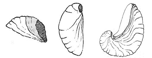
Gryphaea Arcuata Incurva
The final geological history of the parish was shaped in the last few hundred thousand years when there were many glacial periods. Ice movement deposited thin unsorted glacial sands and gravels with transported erratic angular pebbles and flints.
There were warmer periods when hippopotamus, rhinoceros, elephants, and bison roamed the parish as indicated by bone fragments from these animals found in inter glacial gravels. The eastern area of the parish has a thin cover of clean well sorted medium-grained orange brown sand, probably deposited in an interglacial period by a more voluminous predecessor of the River Witham. These sands have uniform properties and are ideal for growing good grass and carrots.
Gradually the ice sheets retreated and vanished from Britain just over 10,000 years ago. The River Witham took its present course through the parish, with falls over buried limestone bands, and deposits of thin layers of alluvial sands and clays with rounded water worn pebbles and freshwater fauna.
The last few thousand years, when man’s history was written down, are a very small fraction of the age of the Jurassic rocks buried beneath the parish.